
#1 in sidewalk scanning and analysis
Inventories through artificial intelligence.
Your ally to monitor and maintain infrastructures with precision and speed. We digitize and analyze the status of urban infrastructures for fast and efficient management.
of sidewalks
of vials
of sidewalks
of vials
Our customers are our best guarantee:
Data management for better decision making.
We extract the location data through AI, represent it on an interactive map and integrate it into a dashboard with Power BI, so you can manage and make decisions visually and efficiently.
100% geolocalized inventory
We segment each image to precisely geolocate each asset, displaying the data on an interactive map of the territory.
Optimization of extraction
We reduce up to 80% the time to obtain the data, without losing control or technical quality. Faster, more accurate and efficient.
Data storage
We obtain, manage and store data in PostgreSQL databases, guaranteeing its organization.
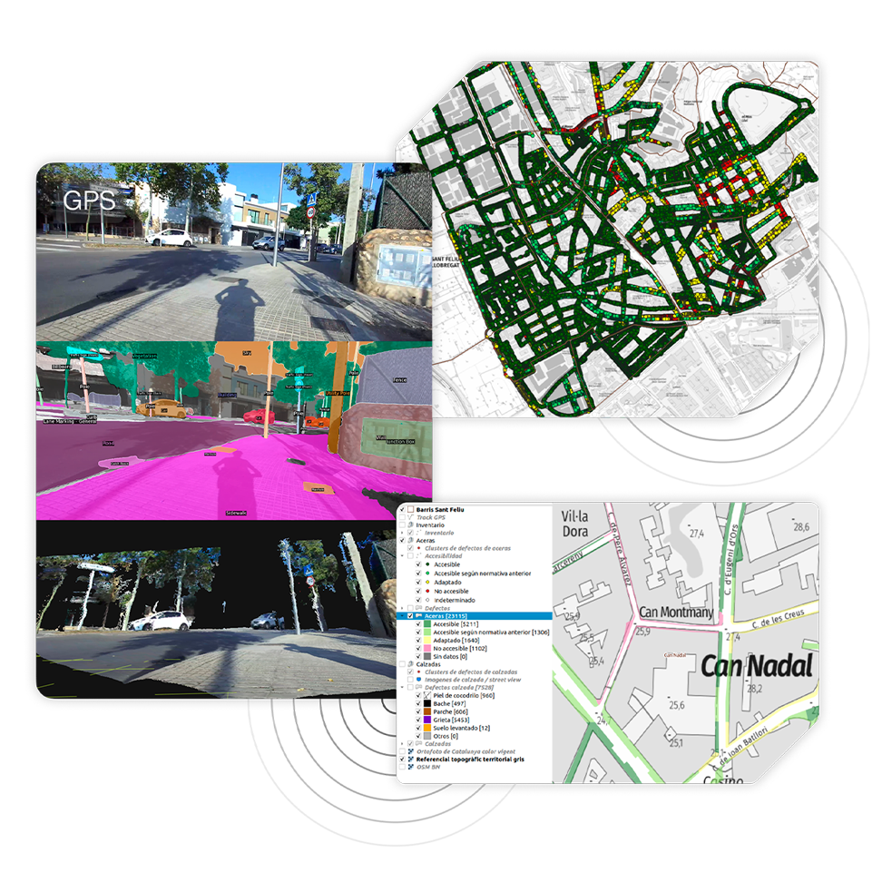
QGIS visualization
Direct integration into QGIS, enabling clear visualization and accurate validation, ensuring quality and reliability from the start.
Budget management
Access accurate data on usage, status and priorities to ensure efficiency in every investment and financial decision made.
Digitized inventory
Connect field and office in real time, and keep your inventory alive, complete, reliable, always accessible and easily manageable.
The technology behind Gemminis
Georeferenced capture, artificial intelligence processing and structured data delivery for advanced analysis and visualization in professional environments.
-
Obtaining
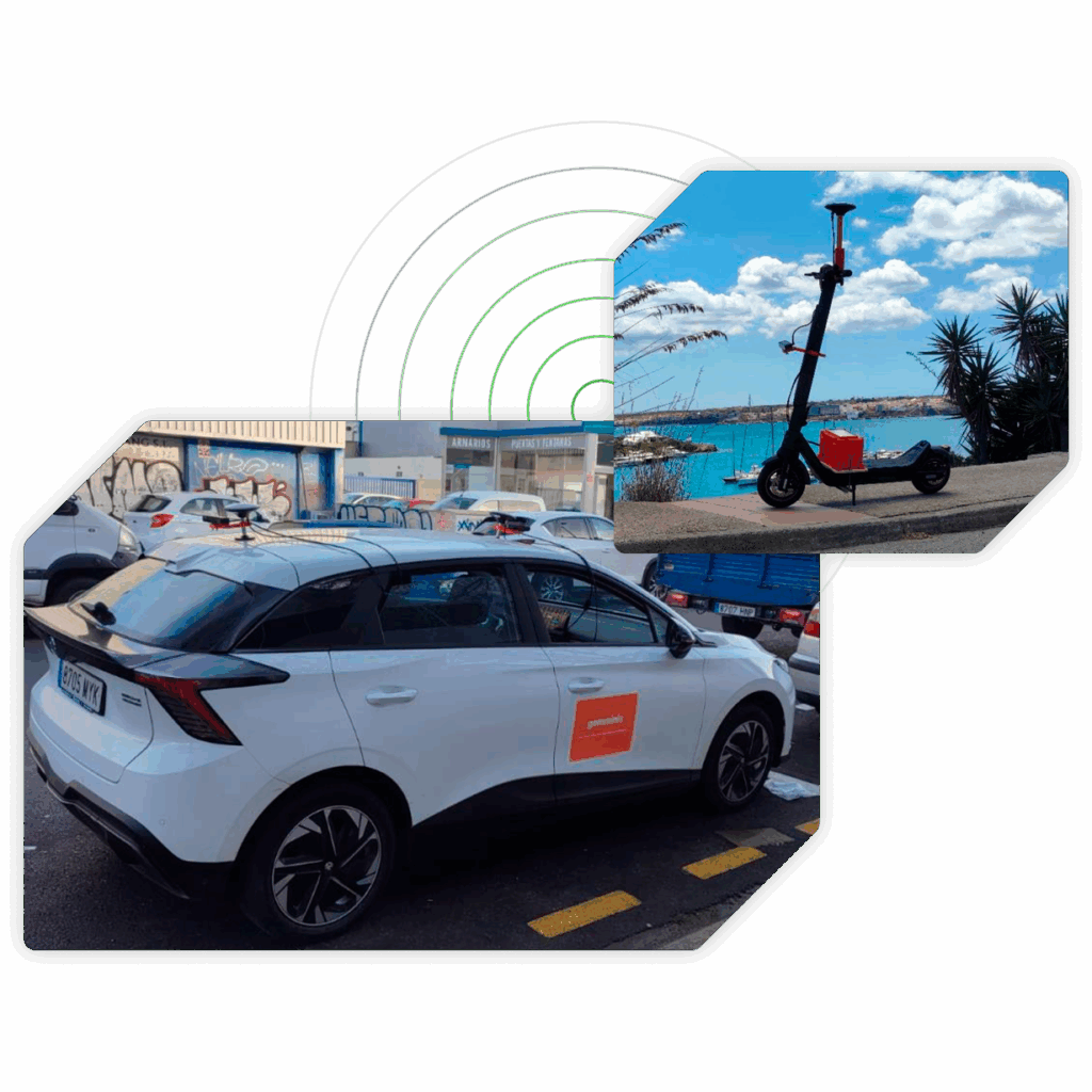
Georeferenced capture
We perform data collection in the field using high resolution cameras and specific sensors. Each image is geolocalized, segmented and assigned precise coordinates for further analysis.
-
Bifocal camera
-
High precision GPS system
-
Inertial system
-
Integrated CPU
-
Remote connection via Internet
-
100% electric vehicles
-
Processing
AI processing and visualization
The extracted data are processed by computer vision and artificial intelligence algorithms. Subsequently, they are integrated into databases PostgreSQL y PostGISdatabases, ready for their technical visualization and validation in QGIS.
-
Geolocalized image
-
Segmentation
-
Coordinates
-
Database
-
Inventory modules
-
Data visualization
-
Validation
-
Management
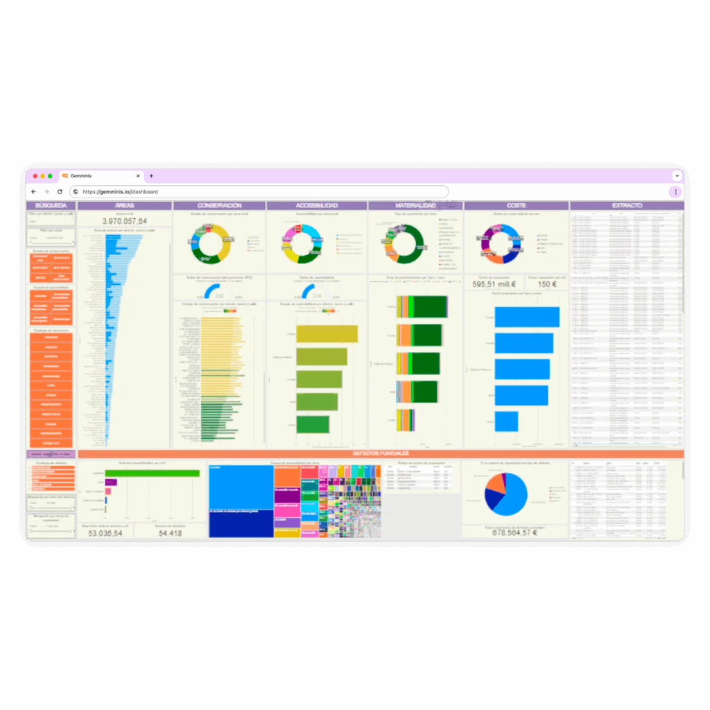
Data management
All the processed information is transformed into an interactive dashboard developed with Power BI. From there, the client can visualize, analyze and make informed decisions in a clear, intuitive and dynamic way.
-
Interactive display
-
Obtaining metrics
-
Dynamic filters
-
Dasboard with graphics
-
Customizable panels
-
Decision making
Advanced modular management system
Discover Gemminis’ key modules that capture, analyze and visualize data on interactive maps through AI and cutting-edge technology. Constantly evolving modules to take your asset maintenance to the next level.
Inventories
With semi-automatic recognition thanks to the implementation of AI.
Trees, traffic signs, street furniture and much more.
Sidewalk conditions
The only module on the market that instantly detects the condition of sidewalk sidewalks, records defects and saves them on maps connected to the customer’s databases.
Track conditions
Analysis of road pavements. Detects defects in real time and records each incident on maps with full traceability to enable review and management.
Accessibility states
Evaluates in real time the accessibility of public spaces, identifying obstacles and barriers to ensure inclusive environments through AI.
Boost your management with artificial intelligence
Discover how Gemminis technology can transform the way you manage your assets. Turn your data into decisions.

